Table of Contents
ArcGIS.com
Since 2025 ArcGIS is provided due to CUNI general licensing agreement.
There is limit of 50 users.
Enrolling of users is coordinated wth ArcGIS supervisor (Clara Sievert clara.sievert@cerge-ei.cz) and done by IT Office ( helpdesk@cerge-ei.cz )
ArcGIS Pro download
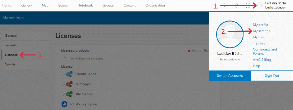
About licensing and credits
Licenses held by CERGE are in the form of year's subscription and allow use of ArcGIS Desktop in off-line mode.
Users who are not in need to use the Arcgis products for they research/study should not have license assigned.
Important: CERGE does not pay for 'premium' services offered by ArcGIS such as online storage, location tracking, geocoding, routing, spatial analysis, business search, demographic maps and layers, infographics, feature reports, scene layer generation etc.
These services are credited while they are used. Users are not supposed to use credits because CERGE did not pay for these credits in the year's subscription and must not be charged extra money later for the credit use (even credits used by mistake).
In general, users MUST pay attention if they are using some online service, even from the ArcGIS Desktop Suite, checking in advance the ESRI website, or consulting with IT or even the ESRI support if it is necessary (IT may provide the contact).
(just for better understanding - one credit is similar to one US dollar)
for more information see https://doc.arcgis.com/en/arcgis-online/administer/credits.htm
Credits are the currency used across ArcGIS and are consumed for specific transactions and types of storage, such as storing features, performing analytics, and using premium content. Any ArcGIS software that interacts with ArcGIS Online, such as ArcGIS Enterprise, ArcGIS Pro, ArcGIS Insights, or ArcGIS Collector can use credits. Most of what you do in ArcGIS Online does not require credits—for example, using ArcGIS Living Atlas basemaps and imagery, exporting data, and performing single address or place searches. In many cases, credit-consuming activities carry a relatively low cost. For example, it costs less than 5 credits to geocode 125 addresses, store 2GB of map tile data, or enrich ZIP Code boundaries in Detroit, Michigan, with four variables of population and income data.
Credits system: https://www.esri.com/en-us/arcgis/products/credits/overview
Following is the extract from the credit system applied by ArcGIS (2021):
| Capability | Example of where used | Credits used | |||
|---|---|---|---|---|---|
| Feature storage, excluding feature attachments, feature collections, and features associated with location tracking | Store a hosted feature layer | 2.4 credits per 10 MB stored per month, calculated hourly. Note: Feature layer settings, such as Enable Sync and Keep track of created and updated features, can increase storage size over time. | |||
| Storage of all content, excluding hosted feature layers and content in ArcGIS Notebooks | Store web maps, Store feature collections, Store attachments in a hosted feature layer, Store published vector tile layers from ArcGIS Pro, Store scene layer packages from ArcGIS Pro | 1.2 credits per 1 GB stored per month | |||
| Storage of all content in an ArcGIS Notebooks workspace | Upload and store content including shapefiles, CSVs, and other files in a workspace | 12 credits per 1 GB stored per month, per user | |||
| Geocoding | Match addresses when publishing spreadsheets (such as CSV or Excel files) as hosted feature layers using ArcGIS World Geocoding Service or a view of this locator | 40 credits per 1,000 geocodes | |||
| Service Areas | Create Drive-Time Areas | 0.5 credits per drive-time | |||
| Closest Facility Routes, Optimised Routes | Find Nearest | 0.5 credits per closest facilities route | |||
| Multi-Vehicle Routes | Plan Routes | 1 credit per vehicle route | |||
| GeoEnrichment Service | Enrich Layer | 10 credits per 1,000 attributes (data variables multiplied by total feature records) | |||
| Location-Allocation | Choose Best Facilities | 0.1 credit per allocated demand point | |||
| Origin Destination Cost Matrix | Generate Origin Destination Cost Matrix in ArcGIS Pro and ArcMap | 0.0005 credits per input origin and destination pair | |||
| Spatial Analysis | Aggregate Points, Join Features | 1 credit per 1,000 features (queried for Find Existing Locations and Derive New Locations). Join Features does not consume credits if you choose the option to create results as a hosted feature layer view. | |||
| Business Search | Search businesses and facilities in Business Analyst Web App | 10 credits per 1,000 records | |||
| Demographic Maps and Layers | Pan ArcGIS Living Atlas Tapestry layer in map | 10 credits per 1,000 map requests (pan, zoom, and identify) | |||
| Infographics | View infographic in ArcGIS Maps for Office | 10 credits per 1,000 views | |||
| Reports | Run reports in Business Analyst Web App | 10 credits per report | |||
| Tile Generation | Build tile cache with ArcGIS Online | 1 credit per 10,000 tiles generated | |||
| Scene Layer Generation From Features | Publish hosted scene layers from hosted feature layers | 1 credit per 5,000 untextured multipatch features or point features | |||
| ArcGIS Notebooks runtimes | Create, open, and run notebooks | 3 credits per hour, per notebook using the Advanced runtime, calculated per minute (10 minute minimum), 30 credits per hour, per notebook using the Advanced with GPU runtime, calculated per minute (10 minute minimum) |
Users of the ArcGIS are not permitted to use such 'premium' credited features.

